
Situated in the province of Pontevedra, the Bay (the Estuary or Ría) of Vigo is the Southernmost of the Galician Rías Baixas (Lower Estuaries).
A ría can be defined as an inlet of the sea in a mountainous area, with a transversal V-shaped profile. The origin of the rías may be tectonic, i.e. the result of the collapse of continental lands, or the consequence of glacio-eustatic processes, with the seas drowning the lower river valleys. The rías are the most salient feature of the Galician landscape, and are divided into the Upper Rías (Rías Altas) to the North, and the Lower Rías (Rías Baixas) to the South.
The Upper Rías include the Northern coast of Galicia (on the Bay of Biscay), the Artabro Gulf (on the North-West corner), and the Coast of Death. Between the municipalities of Ribadeo and Muros are the Estuaries of Ribadeo, Foz, Viveiro, O Barqueiro, Ortigueira, Cedeira, Ferrol, Ares, Betanzos, A Coruña, Corme and Laxe, Camariñas and Corcubión. The Lower Rías are in the South of the Galician Atlantic coast, limited to the North by Muros and to the South by Baiona, and include Muros and Noia, Arousa, Pontevedra and Vigo. The estuaries are deeper at the Lower Rías, and are frequently closed by islands, which protect the bays from the strong influence of the Atlantic Ocean. Thanks to this protection the bottoms of the Rías Baixas are muddy, while those of the Rías Altas are sandy.
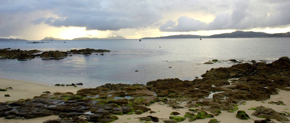
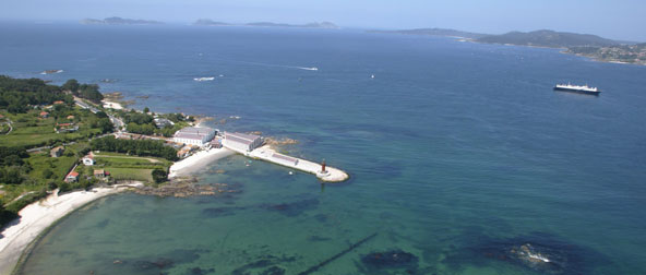
The Bay of Vigo, in the province of Pontevedra, sits on the Southern end of the Galician Rías Baixas. It is one of the largest estuaries, with a total surface of 176 Km2, 33 Km in length (22 miles), and a width of between 10 Km (6 miles) at the entrance of the Bay, between Cape Home and Mount Ferro and just 600 meters (1,970 ft) on the Straight of Rande. It is different from other estuaries (i.e. Muros, Arousa and Pontevedra) in that instead of getting narrow in its inner end, it is narrower at Rande, and then widens again in the area of the of San Simón Island. The Bay spreads across the local boundaries of Cangas, Moaña, Vilaboa, Pontevedra, Soutomaior, Redondela, Vigo and Baiona. The Western Atlantic end is semi-closed by the Cíes Islands, part of the National Park of the Atlantic Islands. Inside of the Bay are the islands of Toralla and the group formed by San Simón and San Antón.
A ría de Vigo, na provincia de Pontevedra, é a máis meridional das Rías Baixas galegas. É unha das maiores de Galicia, cunha superficie de cento setenta e seis quilómetros cadrados, trinta e tres quilómetros de extensión e unha anchura variable entre os dez quilómetros da boca atlántica, entre Cabo Home e Monte Ferro, e os seiscentos metros do estreito de Rande. A diferencia das rías de Muros, Arousa, Pontevedra que se estreitan no fondo, a de Vigo faino en Rande, volvéndose a ensanchar no fondo da ría na enseada de San Simón. A súa costa baña os concellos de Cangas, Moaña, Vilaboa, Pontevedra, Soutomaior, Redondela, Vigo e Baiona. O seu acceso occidental está protexido pola Illas Cíes que forman parte do Parque Nacional das Illas Atlánticas. No interior están as illas de Toralla e as do conxunto de San Simón e San Antón.

Avenida Atlántida 160. 36208 Vigo.
T 986247750
F 986247748
Facebook | Twitter | Contact | Work With Us | Amigos do Museo do Mar